
 High Resolution Microwave Radiometer (HiRad)
Project Description
|
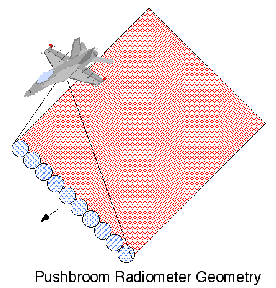
The High Resolution Microwave Radiometer is a interferometric microwave radiometer that uses a synthetic aperture for the remote sensing of the Earth. The purpose of this study is to define the envelope of HiRad instrument parameters required for hurricane wind speed and rain rate measurements. This comprises a trade of geophysical measurement performance versus instrument configuration. The project objective is to design an airborne multi-frequency microwave radiometer operating in a pushbroom mode. The antenna is a thinned aperture array that electronically synthesizes simultaneous spot beams that view the surface from nadir ± 45°. HiRad will fly on hurricane reconnaissance aircraft to measure rain rates and surface wind speeds of hurricanes over open oceans. Because HiRad operates with microwaves, it can "see through the clouds" to measure the surface conditions. |
Technical Description
The sensor will measure brightness temperature of the observed ocean scene. The conceptual rain/wind retrieval is based upon the brightness temperature (Tb) dependence on the surface wind speed (w), rain rate (r), viewing (incidence) angle, frequency, sea-surface temperature, salinity, and other atmosheric parameters. The CFRSL's role is to evaluate models and formulate Tb(w,r) dependence using both electromagnetic theory and a limited set of hurricane experimental measurements. A typical Tb behavior is shown below (Fig. 2). The left panel shows Tb(w) at fixed rain rates and the right panel is Tb(r) at fixed wind speeds. This radiative transfer model (RTM) is obtained based on measurements from the Stepped Frequency Microwave Radiometer (SFMR) instrument developed at University of Massachusetts in Amherst (http://www.ecs.umass.edu/ece/labs/mirsl/).
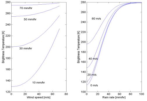
The monotonic brightness temperature increase with both wind speed and rain rate allows an iterative procedure to retrieve wind speed and rain rate assuming an analytical model consistent with these results.
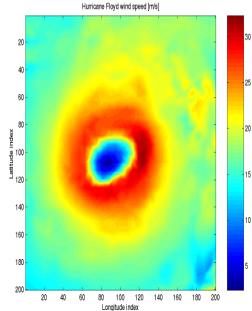
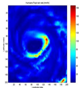
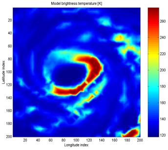
This RTM model uses a realistic hurricane scene and calculates the brightness temperature that would be observed by HiRad. For this simulation, we use actual hurricane conditions for Floyd shown in Fig. 3. Figure 3a is an image of the hurricane Floyd (September 1999) wind speed field, and Fig. 3b shows the corresponding rain rate image. These fields were produced by the NOAA Hurricane Research Division based upon their aircraft flights through Floyd.
 |
 |
A realistic radiometer configuration and sensor geometry (12 km altitude, ±45o scanning from nadir) were used to produce the simulated brightness temperature Fig. 4.
 |
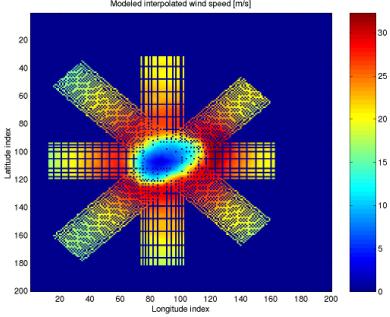 |
The goal of a retrieval algorithm is to invert Tb(w,r) model and produce original w and r fields used to model Tb. The algorithm is simulated using typical hurricane flight geometry (4 passes through the hurricane eye) as shown in Fig 5. The synthesized antenna pattern produced spot beam pixels of 0.008o x 0.008o resolution.
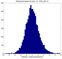
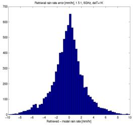
The performance of the wind speed and rain rate retrieval algorithm is evaluated from the simulation statistics summarized in Figs. 6 and 7 respectively. Results demonstrate that the HiRad can meet the desired wind speed and rain rate measurement accuracy (± 10%).
 |
 |
For more information on the HiRad project, please contact Dr. Linwood Jones (ljones@ucf.edu)
Sponsor
Copyright © 1996 L. Jones
Last revision; Feb 2012